Instant, accurate, high-resolution flood maps
Save time in every report with automated maps
If you’re getting maps from FEMA.org or from other sources, you’re wasting about five minutes per map on unnecessary steps. With InterFlood you’ll have full-color, perfectly-sized flood maps automatically added to your reports. They’re always current, provide nationwide coverage, and include the information you need (community, census tract, flood zone designation).
At just pennies per map, there’s no reason why you shouldn’t save yourself time and add “a little extra substance” to your reports. Upgrade to Elite and get 500 flood maps included.
“I add flood maps since many lenders require them. I use them even when they are not required. I believe it gives a little extra substance to the report. I like Interflood because it's easy to use, and I like the way they overlay flood areas on the maps.”
“InterFlood is easy and built into TOTAL. It gives the report a more professional look and offers a document to back up the data entered on the front page of the report.”
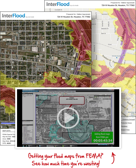
Stop wasting time with government websites and grainy images.
Quickly and automatically download high-resolution, up-to-date flood maps directly into your reports.
| Here’s what’s included | |
|---|---|
| Unlimited Google aerial maps | |
| Custom maps with flood zone data displayed in the color of your choice | |
| Accurate, always up-to-the minute data with the LOMR information from FEMA | |
| Easy readability for your clients with clearly marked streets and a detailed legend | |
| Subject balloon is precisely placed on the map | |
| Automatically added to your report — no more scanning or copying | |
| Properly proportioned and sized for your legal addenda | |
| Includes census data with "scrubbed" address, community, and panel info | |
| Choose between high resolution road and aerial digital maps |